The Silk Road from China - what it was and is
The Silk Road trade was initiated about 2100years ago for trade and travel from China's Han Empire to Central Asia and Europe, and it revolutionized the world until it declined about the year 1368.
What was China's Silk Road
The Silk Road was the world's most significant trade route that connected the East and West for two thousand years.
Yellow River "Huang He"
It started in the yellow river basin where China's first civilization developed. From ancient China capitals, Xi'an and Luoyang, it passed through arid Gansu Corridor and remote West of China, and beyond Central Asia and Europe.
Xi'an (known as Chang'an), located central-northwest China record the great changes in history, just like the living history book. In ancient times, it was one of the birthplaces of China's ancient civilization in the yellow river basin area.
The new rail terminal will define the meeting point between East and West. It will be located at the end of the Silk Road. The new rail terminal is the important gateways to access the country's western region and connecting Beijing, Shanghai, Lanzhou, Urumqi, Guangzhou, Shenzen, Chengdu, Chongqing, and Guilin.
As the Eastern terminal of The Silk Road, the city Xi'an has been the heart of the east and the residence of thirteen Emperors' dynasties.
Towers of ancient city walls in Xi'an, China.
Xi'an, formerly known as Chang'an and once was the imperial capital city, was the eastern departure point for the Silk Road, a hub for traders in China central Shannxi province. These city walls were largely built after the Silk Road and had fallen into unuse. The photo was taken in 2016.
Terracotta Army in Qin Dynasty
Xi'an, also the famous site of the Terracotta Warriors in the Qin Dynasty.
Dun Huang (敦煌, Dūnhuáng)
Dun Huang (敦煌), along the ancient Silk Road, in Gansu province, Northwest China, which sits at the edge of the Gobi Desert. It is situated at a vital strategic and logistical importance, on a crossroads of two major trade routes within The Silk Road network. Lying in an oasis at the edge of the Taklamakan desert. Dun Huang was one of the first trading city encountered by merchants arriving from the West
The Daily Life in Dun Huang
.
The fertile Dun Huang has been millennia a refuge for weary Silk Road travelers. most visitors stayed long enough only to swab camel; but some stayed for building forts, towers, and cave temples that are scattered over the surrounding area.
It was the ancient site of Buddhist religious activities.
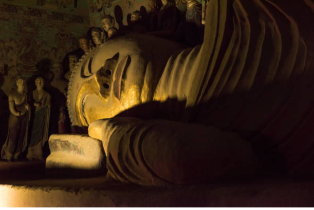
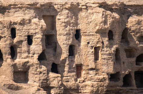
Mogao Caves
The Mogao Caves are a complex of 492 grottoes adorned with Buddhist statuary and frescoes, created between the 4th and 14th centuries. About 40 are accessible to the public.
From the fourth century onwards the 492 largely hand-dug caves near Dun Huang, a desert oasis and crossroads on the Silk Roads, acted as a depository for Buddhist art for around a millennium.
Walked along the ancient path of the Silk Road, looking for the trails of the ancient civilization, you may be stunning by the majestic of the Dunhuang (敦煌) Mural Art.
Those past painters drew the Buddha mural art and left the beauty of the art stagnant here, the magnificent, desolate of the desert gobi, the ancient path with thousand brilliant years, and the millennium of ethnic customs will pass through the future generations.
The Buddhist statues in Mogao caves.
The Mogao Caves, also known as The Thousand Buddha Grottoes, are the best known of the Chinese Buddhist Grottoes and, along with Longmen Grottoes and Yungang Grottoes, listed in the UNESCO World Heritage.
Mogao Grottoes are considered one of the finest and best-preserved examples in the Buddhist arts in the world. They are now the major tourist attractions primarily for Chinese tourists. They were excavated and painted by monks and travelers on the Silk Road from 366AD to the end of the 10th century.
Photo by Zhang Peng / Lightrocket (2018)
Ancient colorful mural arts on the cave wall, telling about the story of Buddhism, are mostly artworks of the Tang Dynasty.
Mandala of the Five- Delty Amoghapasha the infallible laccio painting on silk from the Mogao caves in Dun Huang, China civilization, Tang Dynasty,7th - 10th century. (Photo by DeAgostini / Getty Images.)
 Dun Huang Mogao Grottoes, The Buddha.
 |
| AFP Photo / Ed Jones |
A technician restored the arts in Mogao Caves, Dunhuang.
Mogao Grottoes in Dun Huang

|
The photo was taken by STR/AFP
The tourists were riding camels in the desert in Dun Huang, Gansu, August 2019
|
The Silk Road routes from China to the West passed to the North and South of Taklamakan Desert, and Dun Huang lay on the junction where these two routes came together.
Additionally, the city is situated near the western edge of the Gobi Desert, and North of the
Mingsha Sand Dunes (whose name means Gurling Sands), a reference to the noise of the wind over the dunes. Making Dun Huang becomes a vital resting point for merchants and pilgrims traveling through the region from all of the directions.
Came out from the Mogao Caves, we came to the Ming Sha Shan, Ming Sha singing sand dunes desert.
Dun Huang Ming Sha Mountain (Echo Sand Mountain), a sand mountain range about 40km in length, 20km in width. The highest altitude is 1650m.
Camel caravan in the sand dune.
Sandboarding from top of Ming Sha Sand Dunes (Echo Sand Mountain) is extremely excited with the sand roaring with the wind near your ears.
Crescent Lake with Buddhist temple at Kumtag Desert, Dun Huang, Gansu province.
The aerial view of Crescent Lake (Yue Ya Quan), a moon- shape lake lies at the foothill on the mega sand dunes in the Kumtag desert.
Located about 6km south of the city of Dun Huang in northwest China, the Crescent Lake (Yue Quan in Chinese )is a freshwater spring in the shape of a half-moon.
The oasis, which is believed to have existed for 2000 years, was shrinking fast due to increasing desertification in the region. The ancient oasis was in danger of disappearing beneath the sands until the government stepped in to save it.
The Crescent Buddhist Temple consisted of 4 layers and 6-parties with the wooden construct for each layer, accessible to the fourth layer with the built-in ladder.

The Clifford hanging on the rooftop, filled with love, affection, wishes, and relationship from the visitors
Rocks Formations at Dun Huang Yardang National Geopark, Gansu, China.

The fantastic rock formations at Dun Huang Yardang National Geopark, a site in the Gobi desert located around 180km Northwest of Dun Huang
Jia Yu Guan, The Great Wall, Gansu
Jia Yu Guan is the Western end of the Great Wall built in the Ming Dynasty (1368-1644). It was an important military fortress and also a vital traffic fort along the Silk Road, the world's oldest trading route, connecting China, Central Asia, and Europe.
It was the last stronghold of Imperial China.

The Scenic staff wearing the border soldier's ancient customs issue passports to visitors. |
|
Passports
A Chinese actor was performing the Sabre dance inside the walls of the great wall fortress of Jia Yu Guan, September 2017.
The Auto Silk Way Rally - Moto

|
| The photo was taken by Damien Meyer / AFP |
The Silk Way Rally is an annual rally raid type of off-road race. The racers from all over the world were participating in the Silk Way Rally 2019 from Alashan to Jia Yu Guan in July 2019. Distance: 501.20km.
A mock army like one that would have once occupied the fort.
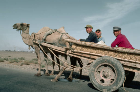
Two Bactrian camels pull a cart making use of an old truck axle and tires, along an empty road near Jia Yu Guan Pass.
Tourist rides the camels at the Gobi near the famed attraction of Jia yu Guan Pass.
A group of camels waiting for rent outside the Jia Yu Guan Pass.
Standing in the endless desert with the rolling mountain as its backdrop, the isolated pass will take you back to the desolation and loneliness of frontier life in ancient times.
Jiu Chuan Satellite
1958, China government built Jiu Chuan satellite in a remote of Gansu province, near part of the old Silk Road. Here, the Shenzhou 9 spacecraft and its carrier rocket are being moved to the launching platform in 2012.
The Great Wall
Part of the Great Wall, built during the Ming Dynasty in Jiayuguan city, Gansu province which is listed by Unesco in 1987. These fortifications were built after the booming of the Silk Road. Jiayuguan, " First Pass under Heaven " as the important hub for the Silk Road in the ancient time,
A large of The Great Wall we saw today was built during the Ming Dynasty (1368 - 1644), West of Yu Men Guan in Dun Huang lies a section dating from the Han Dynasty. (206BC - 220), more than 1300 years earlier than the Ming Dynasty.

Tupopdan Peak
20,033 feet (6106 meters), also known as Passu Cathedral / Passu Cones, located north of Gulmit village in the Hunza valley region of Pakistan Tupopdan, "mouthful of sun mountain" local language The picturesque valley was one of the important passes along the ancient Silk Road, situated between China western Xinjiang region and Afghanistan Wakhan corridor. The photo was taken in 2015.
敦煌
敦煌敦煌